Depressions
Weather Fronts Explained for Sailors — Warm, Cold and Occluded
Published · Last checked October 2026
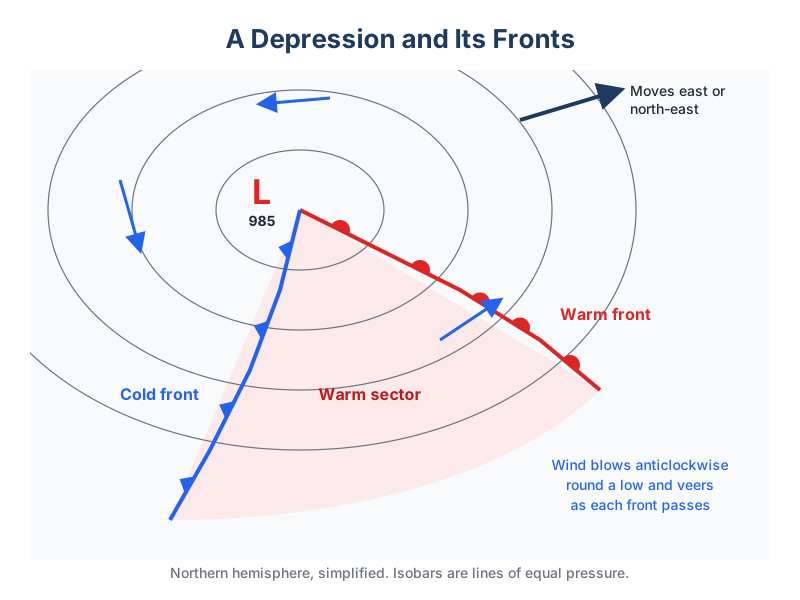
A depression typically brings a warm front then a cold front. Ahead of the warm front the cloud thickens, the barometer falls and the wind backs and freshens, then rain sets in and the wind veers. The warm sector is mild and murky with a steady barometer. The cold front brings squalls, heavy rain and a sharp veer, then the barometer rises and the air clears, with showers and good visibility.

Sequence as a depression passes north of you
| Stage | Barometer | Wind | Cloud and weather | Visibility |
|---|---|---|---|---|
| Ahead of warm front | Starts to fall | Backs, freshens | Cirrus, then cirrostratus | Good |
| Warm front close | Falling steadily | Backs further, increases | Altostratus, rain starting | Moderate |
| Warm front passes | Fall slows | Veers (e.g. SE to SW) | Nimbostratus, steady rain | Poor |
| Warm sector | About steady | Steady SW | Stratus, drizzle | Moderate or poor, fog possible |
| Cold front passes | Rises sharply | Veers sharply (SW to NW), squally | Cumulonimbus, heavy rain | Poor in rain |
| Behind the front | Rising | NW, gusty | Cumulus, showers | Very good |
Occluded fronts
As a depression matures, the faster cold front catches the warm front and lifts the warm sector off the ground: an occlusion. You get a mixture of both fronts' weather, often a long band of rain, without the warm sector between.
Which way will the wind shift?
If the centre of the low passes north of you (the usual UK case), the wind veers. If it passes south of you, the wind backs. Buys Ballot's law helps: with your back to the wind in the northern hemisphere, the low is on your left.
Scrub through a frontal passage hour by hour in the Weather School simulator.