Chartwork
How to Work Out a Course to Steer (CTS) Allowing for Tide
Published · Last checked October 2026
To find a course to steer, draw a line from your start to your destination (the ground track). From the start, draw the tidal stream for one hour. From the end of that line, swing an arc equal to your boat speed until it cuts the ground track. The line from the end of the tide to that point is the course to steer through the water. Then allow for leeway and convert from true to magnetic.
The vector triangle
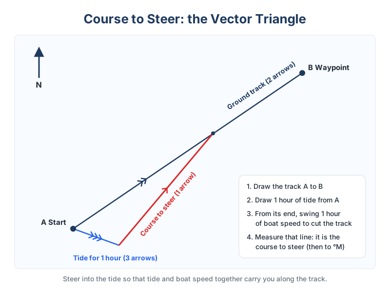
- Draw the ground track from A (where you are) to B (where you want to go), extending it beyond B. Mark it with two arrowheads.
- From A, lay off the tidal stream for the next hour: direction and rate from the tidal diamonds or tidal stream atlas, interpolated for springs and neaps. Mark it with three arrowheads.
- Open the dividers to your boat speed through the water, put one point at the end of the tide line and mark where the other point cuts the ground track.
- Join the end of the tide line to that point. This is your water track (one arrowhead): the true course to steer.
- The distance from A to the cut on the ground track is your speed over ground.
- Allow for leeway: steer a few degrees towards the wind. Then apply variation (and deviation) to get the compass course.
Worked example (illustrative)
You want to go from A to B, 090°T, 10 miles. The stream sets 180°T at 2 knots and you sail at 5 knots. Laying off 2 miles south from A and swinging 5 miles to the track gives a water track of about 066°T. Leeway of 5° with a northerly wind makes it 061°T; variation 2°W gives 063°M. Speed over ground is about 4.6 knots, so the passage takes a little over two hours.
Longer passages
For a passage of several hours, lay off all the hours of tide end to end from A, then swing the distance you will sail in that time. One course to steer for the whole passage is more efficient than correcting hour by hour, because the tide that sets you one way for two hours often sets you back later.
Learn it properly in course plotting with tidal streams and test yourself with the Day Skipper practice exam.