Tides
What Is Drying Height on a Chart? How to Read It
Published · Last checked October 2026
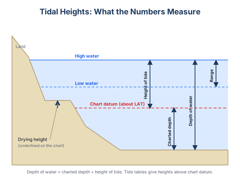
A drying height is the height of the seabed above chart datum on areas that uncover at low water, such as sandbanks, mudflats and rocks. On ADMIRALTY charts it is shown as an underlined figure, usually in the green or buff drying area. To find the depth of water over a drying patch, subtract the drying height from the height of tide. If the height of tide is 3.0 m and the drying height is 1.2 m, there is 1.8 m of water.
How drying heights appear on a chart
Charted depths are measured down from chart datum, but some ground is higher than chart datum and dries out at low tide. These areas are coloured green on ADMIRALTY paper charts (the intertidal zone between the low-water line and the coastline) and the heights are written with a line underneath. An underlined 2₃ means the ground is 2.3 m above chart datum.
| Chart shows | Meaning | Depth with 3.0 m height of tide |
|---|---|---|
| 4₂ | 4.2 m below chart datum | 7.2 m |
| 0₅ | 0.5 m below chart datum | 3.5 m |
| 1̲₂ (underlined) | 1.2 m above chart datum | 1.8 m |
| 3̲₄ (underlined) | 3.4 m above chart datum | Dry |
Working out the depth over a drying patch
- Note the drying height (underlined figure).
- Find the height of tide at the time you will cross, from the tide table and tidal curve or the rule of twelfths.
- Depth = height of tide − drying height.
- Compare with your draught plus a safety margin.
It helps to rearrange the sum when planning: the minimum height of tide you need is drying height + draught + clearance. With a drying height of 1.2 m, a 1.5 m draught and 0.5 m clearance, you need at least 3.2 m of tide, and you can then read off the window from the tidal curve.
Why it matters
Many UK harbours, creeks and anchorages dry, and estuary short cuts often cross drying banks. Drying heights tell you when you can get in, when you must leave, and whether a boat will take the ground at an anchorage. Bilge-keelers and lifting-keel boats can dry out on purpose, but only on a known, flat bottom.